pengenalan
This manual provides detailed instructions for the operation and maintenance of your Garmin GPSMAP 78sc 2.6-Inch Waterproof Marine GPS and Chartplotter. The GPSMAP 78sc series is designed for recreational navigation, featuring a bright 2.6-inch LCD color display, built-in basemap, and a high-sensitivity GPS receiver. All models are waterproof to IPX7 standards and float in water, making them suitable for boating and watersports. Key features include a built-in microSD card slot for additional maps and a dedicated Man Over Board (MOB) button.
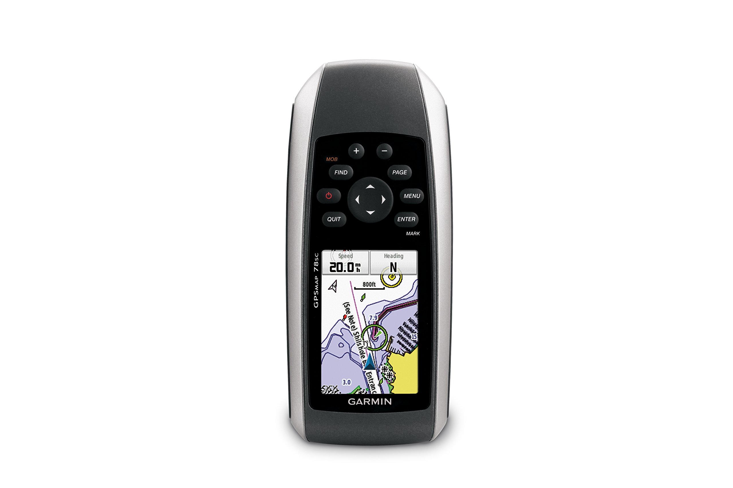
Rajah 1: Depan view of the Garmin GPSMAP 78sc handheld marine GPS and chartplotter.
Produk Selesaiview
Ciri-ciri Utama:
- Marine-friendly handheld with high-sensitivity GPS receiver and 2.6-inch color TFT display.
- Waterproof to IPX7 standards; floats in water.
- Built-in BlueChart g2 U.S./Bahamas coastal charts with shorelines, depth contours, navaids, harbors, marinas, and more.
- Built-in 3-axis tilt-compensated electronic compass and barometric altimeter for heading, altitude, and weather information.
- Wireless sharing of waypoints, tracks, routes, and geocaches with other compatible devices.
Apa yang ada di dalam Kotak:
- GPSMAP 78sc device
- Tali pergelangan tangan
- Kabel USB
- Manual

Rajah 2: Bersudut view of the Garmin GPSMAP 78sc, highlighting its button interface.
Video Produk:
Garmin GPSmap 78 handheld GPS Overview
Video ini memberikan gambaran umumview of the Garmin GPSMAP 78 handheld GPS, demonstrating its features and design.
Produk Selesaiview Video
A concise product overview video from the seller, highlighting key aspects of the device.
Persediaan
1. Memasang Bateri:
The GPSMAP 78sc operates on two AA batteries (not included). To install:
- Cari penutup petak bateri di bahagian belakang peranti.
- Twist the D-ring counter-clockwise to unlock and remove the cover.
- Masukkan dua bateri AA, pastikan kekutuban yang betul (+ dan -).
- Replace the cover and twist the D-ring clockwise to secure it.

Rajah 3: Belakang view of the Garmin GPSMAP 78sc, illustrating the battery compartment.
2. Menghidupkan/Mematikan:
Tekan dan tahan butang kuasa button (located on the left side) to turn the device on or off. A short press will adjust the backlight.
3. Tetapan Awal:
Upon first use, the device may prompt you to set language, time zone, and other preferences. Follow the on-screen instructions using the directional pad and MASUK butang.
Beroperasi
Navigation Basics:
- Menu Utama: Tekan ke MENU button twice to access the main menu.
- Butang Halaman: Tekan HALAMAN to cycle through the main pages (Map, Compass, Trip Computer, etc.).
- Pad Arah: Use the directional pad to scroll through menus, pan the map, or adjust settings.
- Butang ENTER: Tekan MASUK to select an item or confirm an action.
- QUIT Button: Tekan BERHENTI to return to the previous page or cancel an action.
Creating Waypoints:
To mark your current location as a waypoint:
- Tekan ke TANDA butang.
- Edit the waypoint name, symbol, and coordinates if desired.
- Pilih Selesai or Jimat to store the waypoint.
Man Over Board (MOB) Function:
Dalam keadaan kecemasan, tekan butang MOB button to immediately mark the current location and initiate navigation back to that point. This feature is critical for safety in marine environments.
Penyelenggaraan
Membersihkan Peranti:
Lap peranti dengan kain dampened with a mild detergent solution. Dry thoroughly. Avoid using abrasive cleaners or solvents that could damage the device's finish or screen.
Penjagaan Bateri:
Always use fresh, high-quality AA batteries. If the device will not be used for an extended period, remove the batteries to prevent leakage and corrosion.
Kemas Kini Perisian:
Periksa Garmin secara berkala website for software updates to ensure optimal performance and access to the latest features. Updates can typically be installed by connecting the device to a computer via the USB cable.
Menyelesaikan masalah
Peranti Tidak Dihidupkan:
- Pastikan bateri dipasang dengan betul dan dicas sepenuhnya.
- Try new batteries.
- Periksa sesentuh bateri untuk karat.
Poor GPS Signal:
- Pastikan peranti mempunyai jelas view dari langit.
- Avoid areas with tall buildings, dense foliage, or other obstructions.
- Allow sufficient time for the device to acquire satellites, especially after being off for a long period.
Skrin Tidak Responsif:
- Perform a soft reset by removing and reinserting the batteries.
- Pastikan skrin bersih dan bebas daripada serpihan.
Spesifikasi
| Ciri | Perincian |
|---|---|
| Jenama | Garmin |
| Nama Model | peta gps |
| Nombor Model | 010-00864-02 |
| Saiz Skrin | 2.6 Inci |
| Jenis Paparan | LCD |
| Resolusi | 160 x 240 piksel |
| Penilaian Kalis Air | IPX7 (floats) |
| Hayat Bateri | 20 Hours (typical) |
| Jenis Bateri | 2 bateri AA (tidak termasuk) |
| Kapasiti Penyimpanan Memori | 1 GB |
| Compatible Flash Memory Type | mikroSD |
| Sistem Navigasi Satelit yang Disokong | GPS |
| Ciri Khas | Rugged case, Barometric altimeter, Garmin Connect compatible, Electromagnetic compass, Garmin HotFix, Custom POIs, Automatic routing, Hunt/fish calendar, Geocaching, Photo navigation |
| Dimensi Item L x W x H | 2.6"L x 1.2"W x 6"H |
| Berat Barang | 7.7 Auns |
Waranti dan Sokongan
The Garmin GPSMAP 78sc comes with a 1 Year Limited Warranty. For detailed warranty information, product support, or service inquiries, please refer to the official Garmin website or contact Garmin customer service directly. The included manual also contains contact information and further support resources.