
pengenalan
This manual provides essential instructions for the setup, operation, maintenance, and troubleshooting of your Lowrance iFinder Expedition C Plus Waterproof Hiking GPS. Designed for outdoor navigation, this 16-channel handheld GPS unit features a color display, electronic compass, barometric altimeter, and MP3 player capabilities. Please read this manual thoroughly to ensure proper use and to maximize the performance of your device.
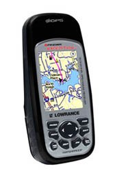
Image of the Lowrance iFinder Expedition C Plus handheld GPS unit, showcasing its color display and button layout.
Persediaan
- Pemasangan Bateri: Open the battery compartment cover on the back of the unit. Insert the required batteries (not included) according to the polarity indicators. Close the cover securely to maintain the waterproof seal.
- Memory Card (MMC/SD) Installation: Locate the memory card slot. Insert the provided MMC/SD memory card, ensuring it is correctly oriented. This card is essential for storing additional maps and data.
- Hidupkan Kuasa Awal: Press and hold the power button until the device screen illuminates. Follow any on-screen prompts for initial setup, such as language selection and time zone.
- MapCreate USA Topo Software Installation: For custom, high-detail mapmaking, install the exclusive MapCreate USA Topo mapping software on your personal computer. Use the provided MMC/SD card reader with a USB connector to transfer maps to your device.
Arahan Operasi
Navigasi Asas
- GPS Signal Acquisition: For optimal performance, use the device outdoors with a clear view of the sky. The 16-channel GPS receiver will automatically acquire satellite signals.
- Peta Viewing: Use the directional pad to pan across the map. Zoom in and out using the dedicated zoom buttons. The 2.83-inch diagonal color TFT display with 320 x 240 resolution provides clear map details.
- Waypoint Creation: Mark your current location as a waypoint by pressing the 'Mark' button. You can name and save these points for future reference.
Ciri Lanjutan
- Mod Pengakap: Activate 'Scout Mode' to mark area perimeters and create custom borders on your map. This is useful for defining hunting grounds, property lines, or exploration areas.
- Kompas Elektronik: The built-in electronic compass provides accurate heading information even when stationary. Calibrate the compass periodically as instructed on-screen.
- Barometric Altimeter: The integrated barometric altimeter provides precise altitude readings and can track changes in atmospheric pressure, useful for weather forecasting.
- Pemain mp3: The device includes MP3 player capabilities. Load your favorite audio files onto the MMC/SD card to enjoy music during your expeditions.
- mikrofon: Utilize the built-in microphone for voice notes or other audio recordings.
Penyelenggaraan
- Pembersihan: Bersihkan peranti dengan lembut, damp kain. Elakkan pembersih atau pelarut yang kasar yang boleh merosakkan skrin atauasing.
- Penjagaan Kalis Air: While the iFinder Expedition C Plus is waterproof, ensure all port covers and the battery compartment are securely closed before exposure to water. Do not submerge the device beyond its rated depth or for extended periods.
- Storan: Apabila tidak digunakan untuk tempoh yang lama, tanggalkan bateri untuk mengelakkan kebocoran. Simpan peranti di tempat yang sejuk dan kering, jauh daripada cahaya matahari langsung dan suhu yang melampau.
- Kemas Kini Perisian: Periksa Lowrance secara berkala webtapak untuk kemas kini perisian tegar bagi memastikan prestasi optimum dan akses kepada ciri baharu.
Menyelesaikan masalah
- Peranti Tidak Dihidupkan:
- Periksa orientasi bateri dan pastikan ia segar.
- Ensure the battery compartment cover is fully closed.
- GPS Tidak Memperoleh Isyarat:
- Bergerak ke kawasan lapang yang bersih view dari langit.
- Allow several minutes for the device to acquire satellites.
- Screen Issues (Dim/Unresponsive):
- Laraskan tetapan lampu latar.
- Perform a soft reset (refer to the device's on-screen menu for instructions).
- Map Data Not Displaying:
- Ensure the MMC/SD card is properly inserted.
- Verify that map files are correctly loaded onto the memory card using MapCreate USA Topo software.
Spesifikasi
| Ciri | Perincian |
|---|---|
| Nombor Model | 112-87 |
| Jenama | Lowrance |
| Saluran GPS | 16-saluran |
| Jenis Paparan | Color TFT with white LED backlight |
| Saiz Skrin | 2.83 Inci (pepenjuru) |
| Resolusi Paparan | 320 x 240 piksel |
| Dimensi (W x H x D) | 5.6 x 2.5 x 1.2 inci (14.2 x 6.35 x 3.05 cm) |
| Berat badan | 8.7 ounces (0.25 kg) / 1.11 kg (shipping weight) |
| Input Antara Muka Manusia | Mikrofon |
| Sokongan Kad Memori | MMC/SD |
| UPC | 042194528304 |
Maklumat Waranti
Warranty details for the Lowrance iFinder Expedition C Plus are typically included with the product packaging or available on the official Lowrance website. Please refer to these resources for specific terms, conditions, and registration procedures.
Sokongan
For further assistance, technical support, or to download the latest software updates, please visit the official Lowrance website. You may also find FAQs and additional resources there to help you with your iFinder Expedition C Plus GPS unit.